Charlestown

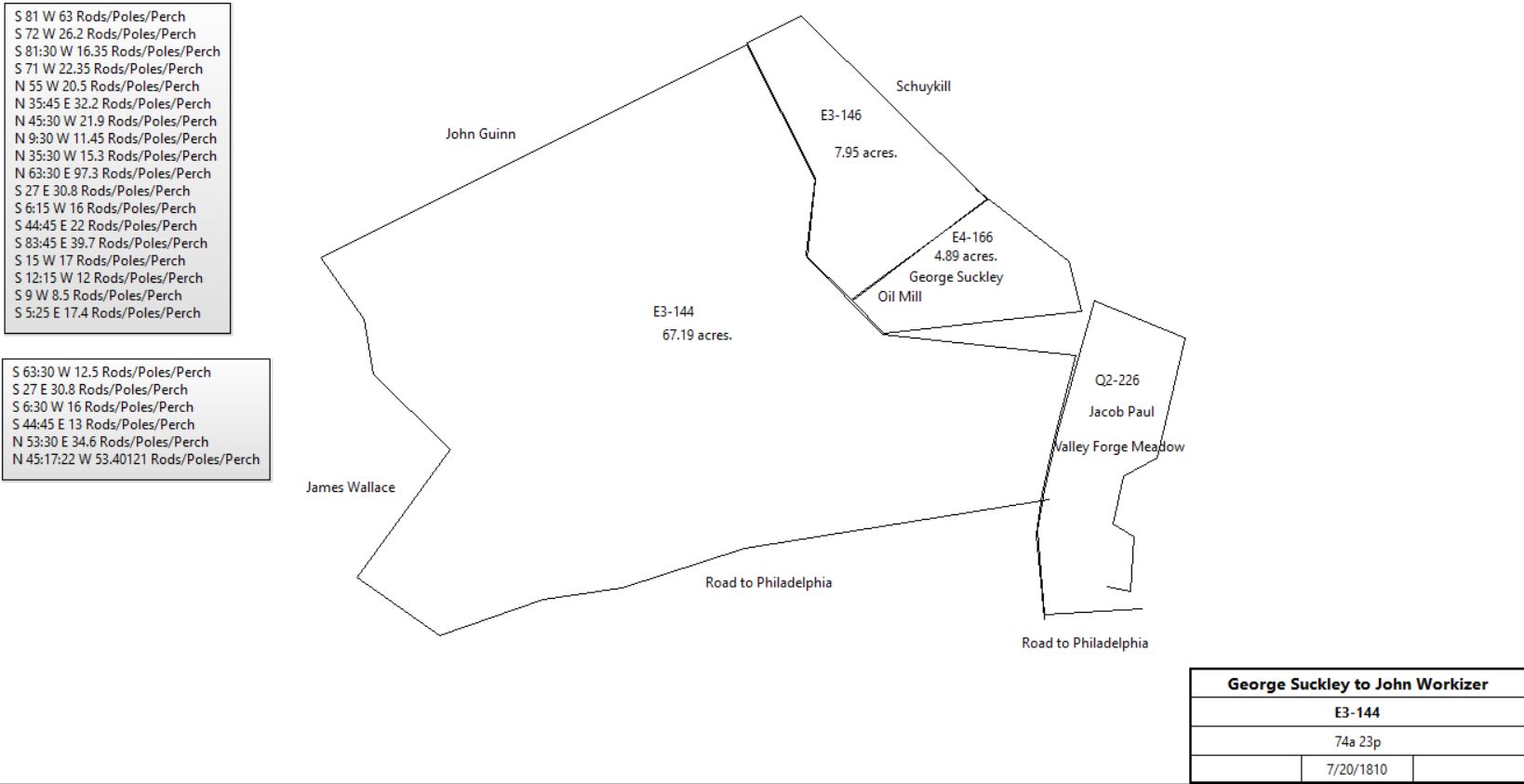
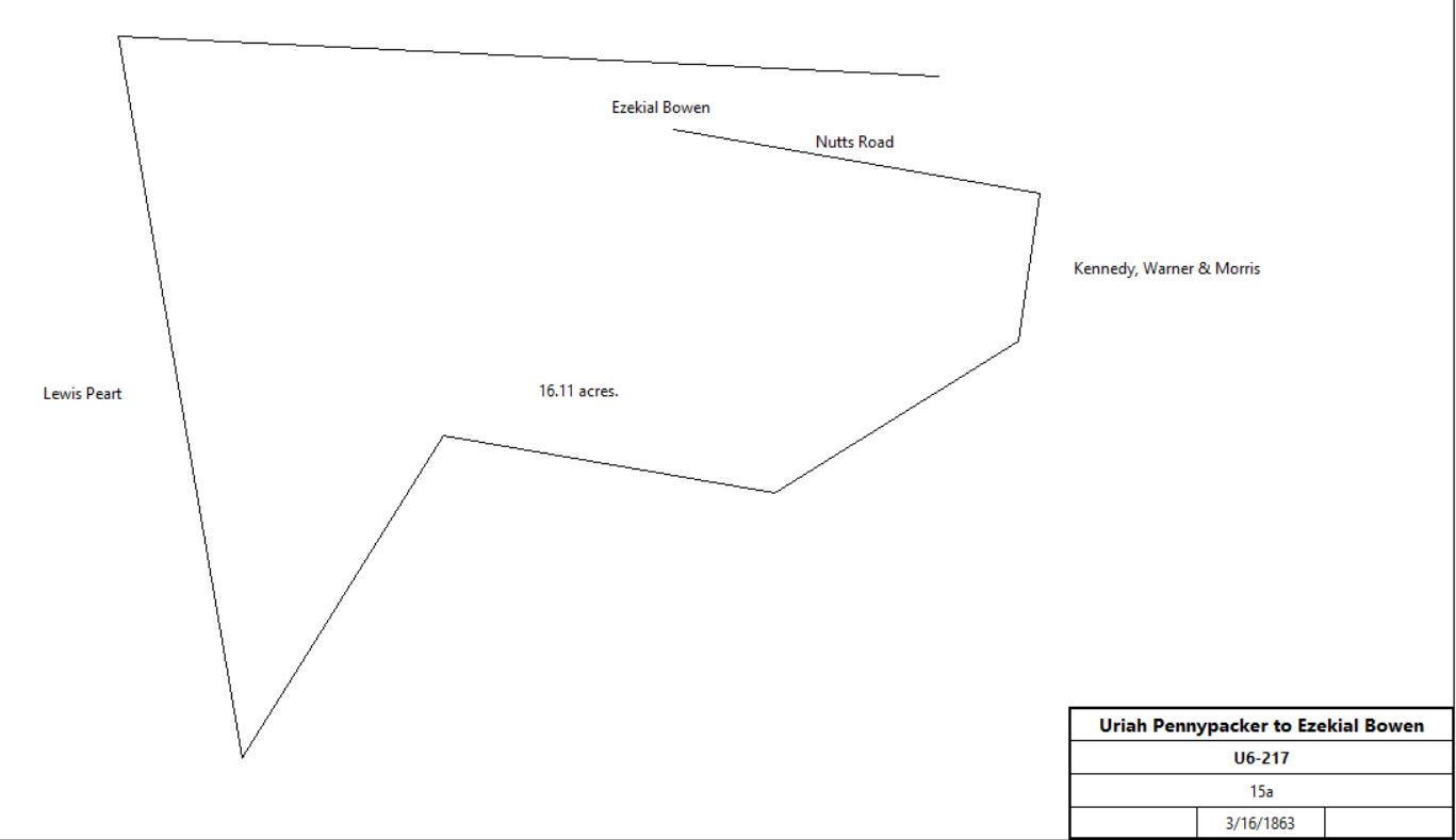
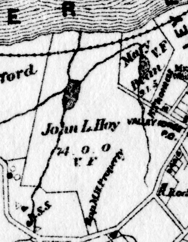
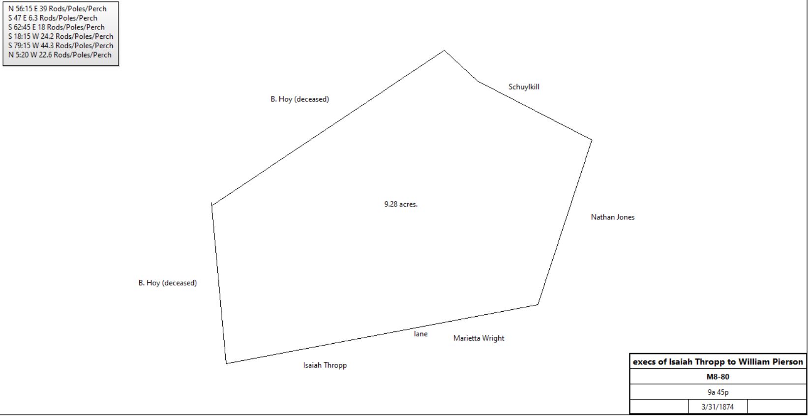
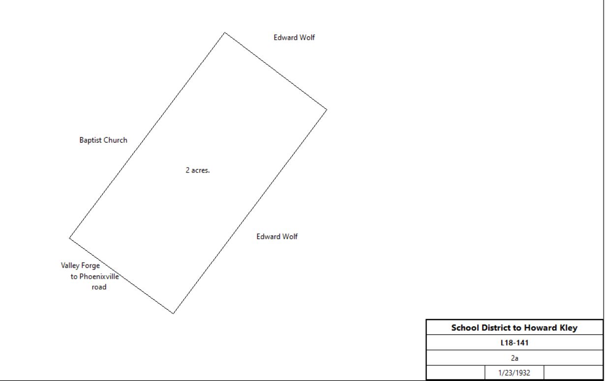
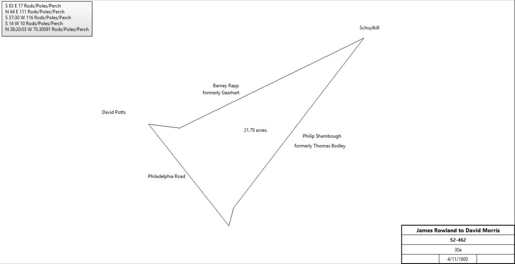
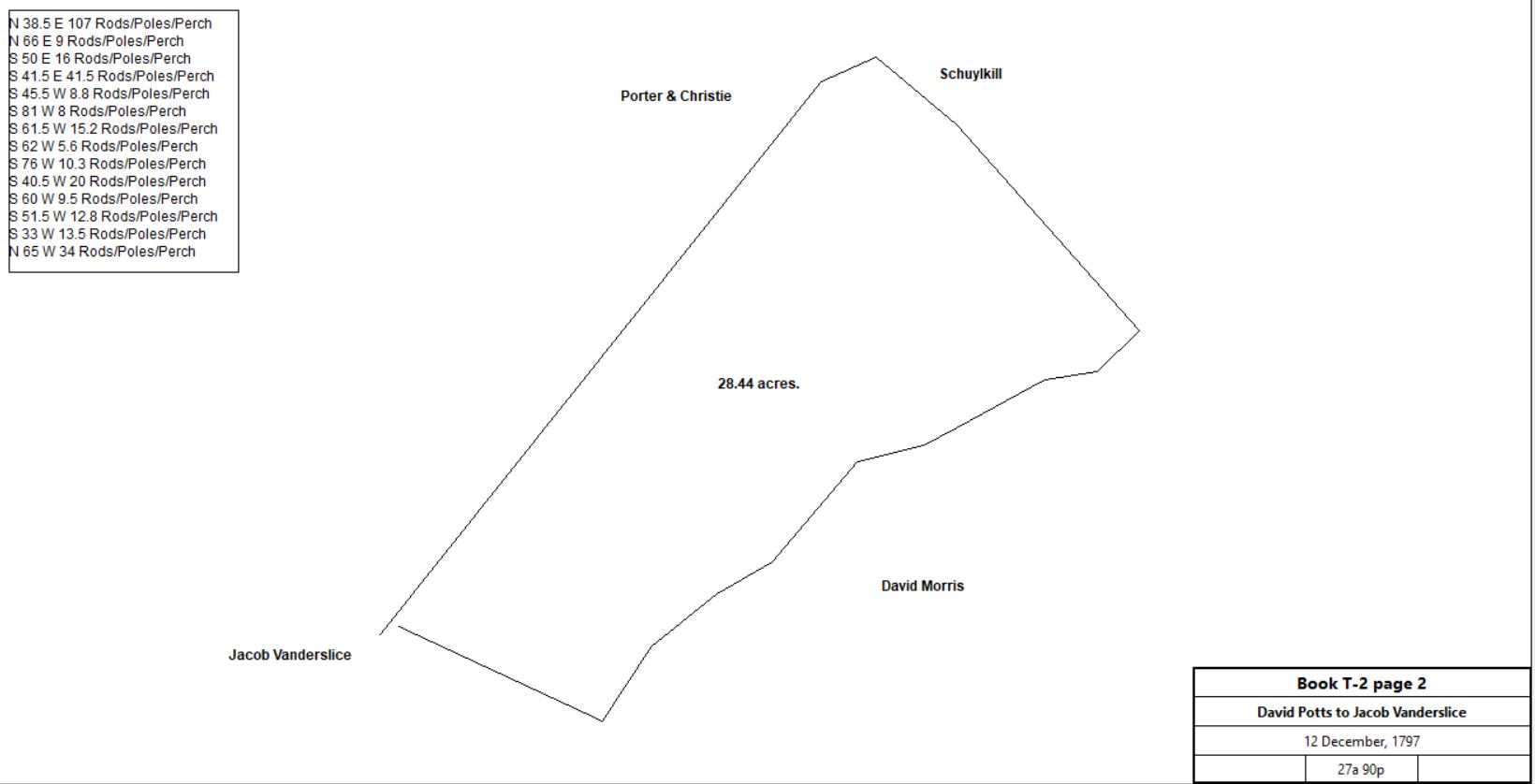
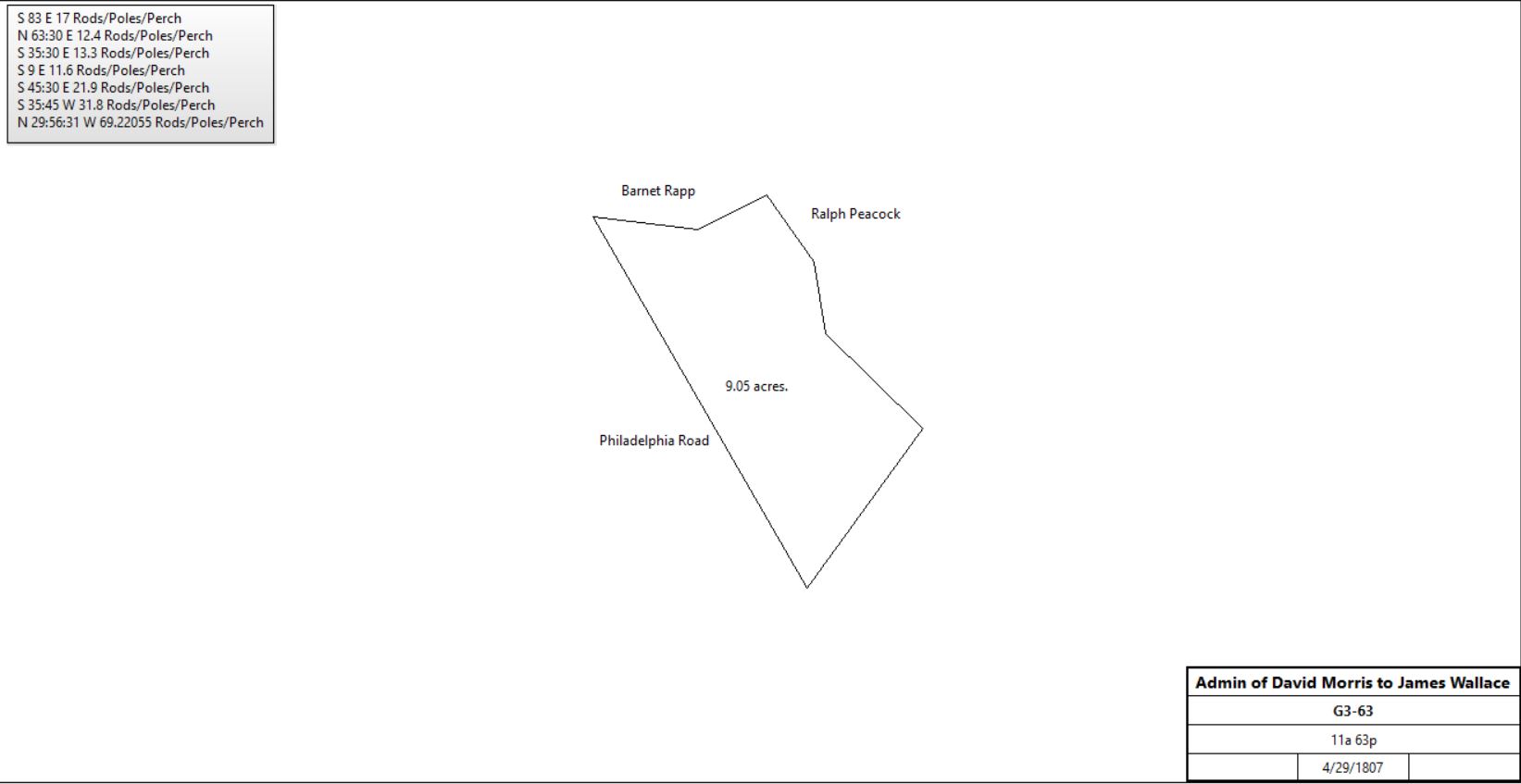
Table 3 - James White Farm


From

To

Date

Area

Cost

Reference


John Jones

Arnst Rafe Snider

12/30/1747

280a


G-230

G-230

Arnst Rafe Snider

William Coleman

12/31/1737


G-232; mortgage

G-232 Mortgage. On 30 Dec 1747 Arnst Rafe Snider of Charlestown, yeoman, to William Coleman & James Pemberton both of the City of Philadelphia, merchants & executors of the will of Samuel Powell, the younger, late of the City of Philadelphia, merchant, dec. Arnst Rafe Snider for £150 granted to William Coleman & James Pemberton a tract in Charlestown bounded by the Welsh Line, land of Daniel Walker & Company, the Great Road, land of David Mathias, Schuylkill River & Valley Creek - containing 280 acres. Arnst Rafe Snider to pay £150 plus interest to William Coleman & James Pemberton, executors of the will of Samuel Powell, in yearly payments to be paid in full on or before 30 Dec 1751. Signed Arnst Rafe Snider. Delivered in the presence of John Fimsey, Joseph Galloway & Samuel Emleson, Jr. Recorded 18 Jan 1747/8.

Sheriff

Thomas Burch

5/27/1752

280a


H-322

H-322 Sheriff’s Deed. On 26 May 1752 William Hay, Esq., High Sheriff of Chester County, to Thomas Burch of the county of Chester. Whereas James Jones, executrix of the will of John Jones in the court of Common Pleas recovered against Arnst Rafe Snyder a debt of £200 & 72 shillings damages to be levied on the goods & lands of Arnst Rafe Snyder. Now William Hay, sheriff, for £136 grants to Thomas Burch a tract in Charlestown bounded by land of Daniel Walker, the Great Road, land of David Matthias, the River Schuykill, Valley Creek & the Welch Tract, containing 280 acres. Signed William Hay, sheriff. Delivered in the presence of Joseph Parker. Recorded 1 June 1752.

Thomas Burch

Daniel Bennizen

5/23/1753

280a

£200

H-547; mortgage

H-547 Mortgage. On 23 May 1753 Thomas Burch of Charles Town, yeoman & Sarah his wife, to Daniel Bennezett of the City of Philadelphia, merchant. Thomas Burch stands bound to Daniel Bennizett for £400 conditioned on payment of £200 plus interest on 23 May 1754. Thomas Burch & Sarah his wife to better secure said payment grant to Daniel Bennezett a tract in Charlestown bounded by the Welch Lone, land of Daniel Walker & Company, land of David Matthias, the River Schuylkill, Valley Creek & the Great Road, containing 280 acres. Signed Thomas Burch & Sarah Burch. Delivered in the presence of Michael Coopin (dutch) & John Bowen. Recorded 18 June 1753.

Pennsylvania Gazette


10/11/1753

280a


A certain messuage, plantation, and tract of land, containing 280 acres , or thereabouts, situated in the township of Charlestown, lying 110 perches on the river Schuylkill, and 53 perches on Valley Creek, joining the lands of Daniel Walker, and Company, being late the property of Thomas Burch.

Sheriff

Robert White

11/29/1753

280a

£224 10s

I-93

I-93 Sheriff’s Deed. On 29 Nov 1753 Isaac Pearson, sheriff of Chester County to Robert White of the County of Philadelphia. Whereas Thomas Lawrence, the younger, in the court of Common Pleas , recovered against Thomas Burch a debt of £372.45 damages to be levied on the lands of Thomas Burch subject to the payment of a mortgage from Thomas Burch to Daniel Benezet of the City of Philadelphia, for the sum of £200 plus interest. Isaac Pearson for £24.10 granted to Robert White all the tenement & tract of land in Charlestown bounded by the Welsh Line, land of Daniel Walker & Company, the Great Road, land of David Mathias & the river Schuykill containing 280 acres. Signed Isaac Pearson, sheriff. Delivered in the presence of John Ross, Thomas Otway, Elisha Price & Henry Hale Graham. Recorded 7 Jan 1754.

Robert White of Gilbert’s Manor, Philadelphia Co

Elizabeth Kerr of Philadelphia, widow

5/9/1761

280a

£200

M-107; mortgage

Robert White

James White

11/26/1771

280a


V-555

V-555

James & Rebeckah White

William Bodley

9/10/1778

280a

£2,076 5s

V-556

William Bodley


1780


died; estate #3359. See Griffith Thomas deed history for a second Bodley tract

Isabel & Thomas Bodley, Administrators of the estate of William Bodley of Charlestown

Alexander McCalla, innkeeper

11/6/1782

280a

£1,260

X-12

Alexander & Margaret McCalla

Thomas Bodley

11/6/1782

280a

£1,260

X-13

Thomas Bodley

Joseph Shambough / Shambo

11/7/1782

139a 82p

£834

X-14

Thomas Bodley of Charlestown

Isaac Potts of Upper Merion, miller

6/19/1784

133a 82p

£450

C2-1

C2-1

Joseph Shambough

Catherine Shambough

1784


died; estate #3624

Catherine Shambough

Philip Shambough

3/30/1786

133a 82p

£3 10s

D2-16

Philip & Lydia Shambough

David Potts

4/20/1796


Deed not found, quoted in S2-458


Branch A

From

To

Date

Area

Cost

Reference


David & Mary Potts

David Morris

8/20/1796

54a 18p

£750

S2-458

S2-458

David Morris


1799

111a


Tax return; Stone Dwelling house 37' x 34'; Stone Kitchen 28' x 17'; Stone Smokehouse 28' x 12'; Stone Dwelling house 18' x 20'; Frame Barrack 14' x 12'; Stone Barn 24' x 30'

Michael Lynch and Thomas Walker, administrators of the estate of David Morris

Ralph Peacock of Philadelphia

4/1/1807

54a 18p & 27a 90p

£1,994

C3-371; see Branch B for a short history of the 27a tract

Sheriff, estate of Ralph Peacock

George Suckley

11/12/1808

85a

£1,300

C3-431

George Suckley of New York, merchant and Catharine Rusten, his wife

John Workizer of Upper Merion

7/20/1810

74a 23p (-8a?)

$4,482 62c

E3-144

George & Catherine Suckley

John Workizer

7/20/1810

8a

$1,400

E3-146

E3-144

John Smith, M. Richard Peters, & Alexander Hampton, assignees of Jacob Vogdes

John Workizer

5/30/1820

15a

$2,000

R3-426; see Branch B.1 of Forge Tracts for earlier history

John & Sarah Workizer

Horatio Gates Jones, Peter Suplee, & Isaiah Thropp

8/2/1834

1a 2p

$1

N4-464; Baptist Church plot

John Workizer

Jamson Amelia Pennypacker (nee Workizer), daughter

1838


$4,542 62c

died

Joseph J. & Jamson Amelia Pennypacker

Uriah V. Pennypacker

1/6/1846

74a 9p + 15a

$7,000

C5-152

Uriah V. & Mary Pennypacker

Joseph J. Pennypacker

2/27/1846

74a 9p + 15a

$7,000

C5-479

Joseph J. Pennypacker

John S. Workizer

4/9/1846

74a 9p + 15a

$7,000

D5-111

John S. & Ann Workizer

Bernard Hoy

3/31/1851

74a 9p

$7,100

N5-238

John S. & Ann Workizer

Sarah Workizer

9/27/1858

15a

$800

K6-95

Sarah Workizer

Uriah Pennypacker

10/6/1862

15a

$1,000

T6-542

Uriah Pennypacker

Ezekial Bowen

3/16/1863

15a

$1,000

U6-217; see deed T8-212 for further history

U6-217

Ezeliel & Elizabeth Bowen

George Hartshaw

1868

0.75a

$80

N7-224

Branch A.1

From

To

Date

Area

Cost

Reference


Bernard Hoy


1864


died

Estate of Bernard Hoy

John L. Hoy

3/3/1880

74a 9p

$4,740

G9-102

John Hoy, 1883
John Hoy tract from Breou’s atlas, 1883

John L. Hoy


1883

74a


Breou’s Atlas

John & Tilley Hoy

Eastern Real Estate Company

4/4/1903

1.79a

$650

O12-234; next to Schuylkill

John L. Hoy

Thomas C. Stewart & Frederick Wolf

6/1/1911

69a

$19,000

H14-34

Sheriff

Edward Wolf

2/1/1918

69a

$100

C15-508

Edward & Clarice Wolf

Valley Forge Baptist Church

12/26/1925

27,540 ft2

$450

G17-524

Edward Wolf

Mary G. Archer

4/25/1929

66 1/3a

$1

H18-6

Mary Gertrude Archer & Frederick Wolf

Commonwealth of Pennsylvania

8/3/1945

59.21a

$1

A22-384; see Branch D for remaining property

Branch A.2

From

To

Date

Area

Cost

Reference


John & Sarah Workizer

Isaiah Thropp

2/28/1831

12a 36p

$600

E4-164; part of E3-144 (see above)

George Suckley

Isaiah Thropp

6/1/1831

4.5a

$450

E4-168; see Branch E for earlier history

Isaiah Thropp


1871


Died

Joseph Thropp & Elijah Pennpacker, executors of the will of Isaiah Thropp

Marietta Wright

3/28/1874

1a 86p

$600

M8-314, see table A.1.b for continuation

Executors of the will of Isaiah Thropp

William Pierson

3/31/1874

9a 45p

$5,500

M8-80; E4-168 and remainder of E4-164

M8-80

William Morrison, sheriff, debt of William Pearson

Executors of the will of Isaiah Thropp

8/12/1875

9a 45p

$1,000

Sheriff’s deed 7-386, includes mill

Executors of the will of Isaiah Thropp

Catharine Glathery or McGlathery

12/1/1876

6a 11p

$1,213 75c

V8-408; part of 12a 36p above

V8-408

Executors of the will of Isaiah Thropp

Mary Jane Bean

3/19/1881

9a 45p

$2,000

L9-424

Mary Bean, 1883
Mary Bean tract from Breou’s atlas, 1883
for sale see Forge Tracts

Michael Towers (assignee of Mary Jane Bean)

Mortimer Bickley

9/12/1899

1) 9a 45p (Thropp Mill see L9-424)

plus other tracts (see Bean for full list of properties)

$8,350

A12-22

Mortimer & Caroline Bickley

Philadelphia & Reading Railroad Co.

4/14/1910

1.28a

$392

Z13-14

Milton & Mary Bickley, Walter & Josephine Bickley, Mary & Henry Robinson, heirs of Mortimer Bickley

Francis M. Bean

4/1/1913

1) 9a 45p, excluding 0.128a sold to Reading Railroad

$25,100

K14-312

Branch A.2.a - north side of route 23

From

To

Date

Area

Cost

Reference


Joseph & Catharine Glathery

Benjamin R. Thomas

3/19/1879

8,500 ft2

$100

D9-110; lot #9

Joseph & Catharine Glathery

Benjamin R. Thomas

8/3/1879

8,500 ft2

$100

A9-51; lot #10

Benjamin R. & Jennie Thomas

Phebe Mulvaney

3/25/1895

8,500 ft2 + 8,500 ft2

$875

H11-88

Heirs of Phebe Mulvaney, Charles & Eleanor Mulvaney and Lewis Free

John Mulvaney

7/27/1896

3/8 of (8,500 ft2 + 8,500 ft2)

$1,500

R11-58

Guardian of Laurie Free

John & George Mulvaney

8/20/1896

1/8 of (8,500 ft2 + 8,500 ft2)

$500

R11-55

John & George Mulvaney

Laura Kirkner

11/17/1904

8,500 ft2 + 8,500 ft2

$1,000

T12-238

Laura K. Samuel

Morris Ray

11/2/1912

8,500 ft2 + 8,500 ft2

$1,950

O14-58; see Branch A.2.g for continuation

Branch A.2.b - north side of route 23

From

To

Date

Area

Cost

Reference


Joseph & Catharine McGlathery

Augustes Reiman

4/23/1878

29,658 ft2

$375

A9-47, Lots #7 & 8

A. Raymond


1883


Breou’s atlas

William Baker, sheriff, debt of August Reiman

Henry Stockman

1/1/1884

0.5a

$361

Sheriff’s deed #9-113

David Hause, Trstee of the estate of Marietta Wright

William Crawford

3/9/1886

1a 86p + 80.5p


B10-493

Henry & Sabina Stockman

William Crawford

7/12/1886

29,658 ft2

$250

E10-122

William & Henrietta Crawford

Davis Hause

3/25/1887

1a 86p + 80.5p + 29,658 ft2

$2,300

G10-18

Davis & Catharine Hause

Henrietta Crawford

3/25/1887

1a 86p + 80.5p + 29,658 ft2

$2,300

G10-19

William & Henrietta Crawford

Nicholas Bean

11/1/1889

1a 86p + 80.5p + 29,658 ft2

$300

S10-121

S10-121

Nicholas Bean


~1890


Died intestate, administration 1890

Winfield & Mary Jarrett

Mary Jane Bean

3/2/1897

1a 86p + 8.5p + 29,658 ft2

$1

M11-203

Mary Jane Bean Nichols

Jerome & Mathilde Shea

4/18/1913

1a 86p + 81.5p

$3,200

P14-33

Nicholas Bean

Mary Jane Bean

2/4/1890

1a 6p

$250

Y10-259

Y10-259 not found

Mary Jane Bean Nichols, widow

Mathilda Sheas

11/9/1914

1a 6p

$400

V14-261

Mathilde & Jerome Sheas

Commonwealth of Pennsylvania

6/25/1919

0.526a

$131

D16-511; part of condemnation proceedings

Jerome Sheas

Mathilde Sheas

8/17/1922

not quoted

$1

D16-8; V14-261 and part of P14-33

Mathilde Sheas, widow

Samuel R. & Marion J. Brittain

12/26/1947

0.811a

$1

X23-76

Mathilde Sheas, widow

Commonwealth of Pennsylvania

2/4/1955

0.77a

$9,000

X24-63; Allows Mrs Sheas to live in the house during her lifetime

Samuel & Marion Brittain

Commonwealth of Pennsylvania

1/13/1958

0.809a

$2,725

W29-124;


Mary Jane Bean Nichols

Margaret Lincoln Lund

9/30/1909


X13-68; Lot #7

Margaret Lincoln Lund

Ebenezer Lund

7/17/1934


died

Ebenezer Lund

Florence Clegg & Laura May Lund Highley

3/5/1935


died

Florence Clegg & Laura May Lund Highley

Fred & Ruth Midgley

9/9/1968

29,658 ft2

$14,500

K38-307

Fred Midgley

U.S.A.

11/4/1980


512-438

Branch A.2.c lots 5 & 6 - north side of route 23

From

To

Date

Area

Cost

Reference


Joseph & Catharine McGlathery

Mary Hayman

3/28/1877

96 1/3p

$330

X8-276, Lots #5 & 6; part of V8-408 (see above)

X8-276

Mrs Hamen


1883


Breou’s atlas


L36-320

Ronald & Mary Anne Houck

U.S.A.

6/6/1978

0.6a

$71,000

H52-324

Branch A.2.d - Lot 4- north side of route 23

From

To

Date

Area

Cost

Reference


Joseph McGlathery

Joseph Orner

12/1/1910


X13-540; part of V8-408

X13-540


P48-66

Dorothy & William Dombert

U.S.A.

10/12/1977

0.36a

$59,500

W51-549

Branch A.2.e lots 1, 2, 3 - north side of route 23

From

To

Date

Area

Cost

Reference


Joseph & Catharine McGlathery

Isaac Smith

2/27/1877

26,232 ft2

$325

U8-291; Lots #1 & 2

Joseph & Catharine McGlathery

Isaac Smith

7/31/1877

7,378 ft2

$100

Y8-49; Lot 3

U8-291

Isaac & Mary Smith

Jane Dunn

6/4/1883


$2,500

T9-254

Mrs Dunn


1883


Breou’s atlas

Jane Dunn

Ella Boyer

4/24/1886

33,610ft2

$2,500

C10-243


A37-1033

John & Mary Halpine

U.S.A.

6/2/1978

0.77a

$55,200

Z52-89

Branch A.2.f - north side of lots #9 and #10

From

To

Date

Area

Cost

Reference


Joseph McGlathery

Nicholas Bean

10/1/1886

130,696 ft2

$612 50c

E10-465; part of V8-408

Nicholas Bean

Mary Jane Bean

1/1/1887

130,696 ft2

$612 50c

W10-98

Mary Jane Bean Nicholas

Benjamin F. Bean jr.

8/1/1913

0.701a

$350

T14-16; part of W10-98

Mary Jane Bean Nichols

M. Jane Garrett

2/16/1924

not quoted

$1

M16-53; remaining part of W10-98 between Benjamin Bean's and Mrs. Sheas land.

M. Jane Garrett

Commonwealth of Pennsylvania

11/18/1941

not quoted

$600

Q20-334

Branch A.2.g - Orchard Lane

From

To

Date

Area

Cost

Reference


Mary Jane Bean

Aaron Robinson

10/10/1914

3977 ft2?

$500

C15-469

Aaron Robinson

Morris Ray

12/11/1917

39770 ft2

$1,000

C15-470

Morris & Catharine Ray

George Rowan

3/30/1918

39770 ft2 + 8,500 ft2 + 8,500 ft2

$3,125

O15-58; 3 plots on Orchard Lane; see Branch A.2.a for earlier history of smaller tracts


O30-275

Sabina Setzler

U. S. A.

3/10/1978

1.39a

$86,500

O52-315

Branch A.2.h

From

To

Date

Area

Cost

Reference


George Suckley of New York, merchant and Catharine Rusten, his wife

John Workizer

7/20/1810

74a


E3-144 & E3-146; See James White Farm. Note that this tract is north of Nutt’s Road while the 80.5p tract is south

John & Sarah Workizer

Brook Evans, in trust for the use of Mary Truman

2/13/1824

80.5p

$80 50c

X3-127

X3-127

Brook Evans, Manufacturer

Abishai Woodman

8/5/1825

80.5p

$1

Y3-299

Abishai Woodman, inn holder & trustee of Mary Truman

Simon Antry

6/4/1832

80.5p

$700

E4-620

Major McVeigh, assignee of Simon Antry

James C. Ogden

3/24/1847

80.5p

$1,000

F5-44

Jacob Heffelfinger, sheriff, debt of James Ogden

Matthew Ross

8/16/1860

80.5p

$5

Sheriff’s deed 6-211

Matthew & Susannah Ross

Bernard McMeniman

3/30/1865

80.5p

$950

G7-45

Bernard & Bridget McMeniman

Matthew Ross

7/20/1868


Matthew Ross

James F. Hoy

7/24/1868

80.5p

$550

N7-98

James & Madaline Hoy

George Wright

11/6/1868

80.5p

$1,400

O7-18

George Wright


1873


Witmer’s atlas

George & Marietta Wright

Isabel McGlathery

5/22/1871

80.5p

$1

B8-124

Isabel McGlathery

Marietta Wright

5/22/1871

80.5p

$1

B8-125


Mrs White


1883


Breou’s atlas; no purchase deed found

Branch A.2.i

From

To

Date

Area

Cost

Reference


Joseph Thropp & Elijah Pennypackerl, Executors of the will of Isaiah Thropp

Annie Blair

7/10/1875

13,080 ft2

$200

V8-324

U8-291

Isaac Smith, administrator of the estate of Annie Blair

John Blair


John Blair

Sarah Auch

3/22/1879

13,080 ft2


D9-111

Sarah Hawk


1883


Breou’s atlas

Sarah Auch


6/22/1890


Died intestate

William Whitehead et al

John F. Auch

4/6/1901

13,080 ft2

$875

G12-221

John Auch

Howard Williams

5/3/1901

13,080 ft2


H12-439

Howard & Lillian Williams

Mortimer Bickley

9/12/1901

13,080 ft2

$1,300

L12-145


R22-173

Robert & Helen Brazier

U.S.A.

10/13/1977

0.30a

$56,000

W51-555

Branch A.2.j - Orchard tract

From

To

Date

Area

Cost

Reference


Nicholas Bean

Mary Jane Bean

1/1/1887

3a 0.5p

$612 50c

W10-98


T14-16


G15-454


P16-6


D17-86

Branch A


U18-514


P30-340

Margaret K. Rowan

U.S.A.

10/6/1977

0.14a

$27,000

W51-83

Margaret K. Rowan

U.S.A.

10/27/1982


$1

Y60-266; quitclaim

Branch B


L4-421

Ronald & Mary Anne Houck

U.S.A.

12/16/1977

0.46a

$33,000

E52-362

Branch A.2.k - Mill tract

From

To

Date

Area

Cost

Reference


John Workizer

Isaiah Thropp

2/28/1831

12a 36p

$600

E4-164

Goerge Suckley

Isaiah Thropp

6/1/1831


E4-186; deed not found

Joseph Thropp & Elijah Pennypacker, executors of the will of Isaiah Thropp

William Pierson

3/31/1874

9a 45p

$5,500

M8-80

William Pierson

Mary Bean


deed not found

Mary Bean


1883

9a 1r 5p


Atlas

Bickley


1906

9a 45p


plan

Pine Iron works

Paul Lemen

4/24/1946

31 tracts

Schuylkill: #1: 9a 45p - 0.128a (Throp's mill);


S21-217

Valley Forge State Park


1950


Atlas; Includes 9a 45p tract

Branch A.3 - 19th century School

From

To

Date

Area

Cost

Reference


John & Sarah Workizer

John Morgan, Edward Garrigues, Joseph Pennypacker, Lewis Roberts, William Conard, and Moses(?) Robinson, school directors of Schuylkill township

1/30/1836

40p

$35

R4-686

R4-686 failed to load

The School District of Schuylkill township

Frank & Kate Bode

8/31/1921

40p

$1,100

V15-512

Branch A.4 - 1920s School

From

To

Date

Area

Cost

Reference


Sheriff, Clarence Otlip, debt of Thomas C. Stewart and Frederick Wolf

Edward Wolf

2/1/1918

69a

$100

C15-508; see Branch A above for earleir history.

Edward Wolf

School District of Schuylkill township

10/7/1921


$2,500

Miscellaneous 13-337; Condemnation

School District of Schuylkill township

Howard Kley

1/23/1932

2a

$1

L18-141

L18-141 failed to load

Howard Kley

Philip Zuiderhoek and Fred Lyle

6/28/1937

2a

$1

X19-51

Philip & Virginia Zuiderhoek and Fred & Genevieve Lyle

Commonwealth of Pennsylvania

12/12/1941

2a

$4,484

S20-282

Now the location of Valley Forge post office

Branch B

From

To

Date

Area

Cost

Reference


David and Mary Potts of Upper Merion

Jacob Vanderslice of Charlestown

12/12/1797

27a 90p

£225 12s 6d

T2-2

T2-2

Jacob Vanderslice of Charlestown

David Morris, storekeeper, of Charlestown

2/30/1798

27a 90p

£358 6s 3d

T2-4

David Morris


1799

111a


Taxes; Stone Dwelling house 37' x 34'; Stone Kitchen 28' x 17'; Stone Smokehouse 28' x 12'; Stone Dwelling house 18' x 20'; Frame Barrack 14' x 12'; Stone Barn 24' x 30'

See Branch A for continuation

Branch C

From

To

Date

Area

Cost

Reference


Isaac Potts of Cheltenham, Gentleman and Thomas Harrison of Phildelphia, Tailor, surviving executors of the will of Norris Jones

James Rowland

3/28/1800

30a


S2-459

James Rowland

John Vanderslice


sold but did not effectively convey; quoted in S2-462

John Vanderslice

David Morris


quoted in S2-462

James & Rachel Rowland of Philadephia, Merchant

David Morris of Charlestown

4/7/1800

30a

£300

S2-462

S2-462

David Morris, deceased

James Wallace

4/29/1807

11a 63p

£300

G3-63

G3-63

James Wallace

Alexander McCurdy

4/1/1834

? + 3a 47p

$700

K4-66

Alexander McCurdy

John McConaghy, nephew

5/11/1857 (will)

12a


died; all my real estate. Mentions messuage, shop, and 12 acres of land

John & Mary McConaghy

Samuel Pennypacker

3/29/1858

11a 63p

$2,225

I6-32

Samuel & Margaret Pennypacker

Randolf Supplee

4/1/1859

11a 63p

$2,375

L6-377

Randolf & Catharine Supplee

Nicholas Bean

4/1/1861

11a 63p

$2,300

T6-332

Nicholas & Mary Ann Bean

Frederick Auch

4/1/1864

11a 63p

$2,250

X6-384

Nicholas Bean, administrator of the estate of Frederick Auch

Isaac Shaw


deed not found; quoted in E7-364

Isaac & Nancy Shaw

Evan Vanderslice

7/26/1866

11a 63p

$405 25c

E7-364

Thomas & Ella Peart (nee Vanderslice)

L. Ellwood Vanderslice

5/25/1899

½ part of 11a 63p

$2,000

X11-219

Branch D - south of route 23

From

To

Date

Area

Cost

Reference


Commonwealth of Pennsylvania

8/3/1945


A22-334; see branch A.1 for earlier jhistory

Frederick Wolf


10/9/1966


died

Mary Archer & Executors of Frederick Wolf

William Wilson & Dominick Basquale

8/11/1967


$50,000

S37-667; Mansion house property

William Wilson & Dominick Basquale

Commonwealth of Pennsylvania

11/19/1979

7a

$210,000

A56-176

Branch E - Oil Mill

From

To

Date

Area

Cost

Reference


George Suckley & Catherine Rietsen, his wife

Daniel Brode

7/16/1813

4.5a


Deed not found; quoted in E4-166

Daniel & Abigail Brode

Rietsen Suckley

6/6/1829

4.5a

$1,000

E4-166 (Oil Mill)

E4-166

Rietsen Suckley

George Suckley

5/14/1831

4.5a

$1

E4-167 (Oil Mill by Schuylkill)

George Suckley

Isaiah Thropp

6/1/1831

4.5a

$450

E4-186

Penn Mining & Smelting Company


1851


Map; see table A.1 for continuation